(Position at February 2026)
Background
The existing A29 currently experiences traffic congestion during peak periods, especially at the Woodgate level crossing. This has led to unreliable journey times and queuing vehicles, affecting air quality.
The A29 realignment scheme is an important part of the aims for Arun District, as outlined in the West Sussex Transport Plan. The Coast to Capital Local Enterprise Partnership (LEP) also shares this vision in its Strategic Economic Plan.
The Barnham, Eastergate and Westergate areas have been identified as requiring additional infrastructure to support planned local development in the Arun Local Plan. Therefore, West Sussex County Council has commissioned a feasibility study to refine the design presented in the Arun Local Plan.
The proposed scheme
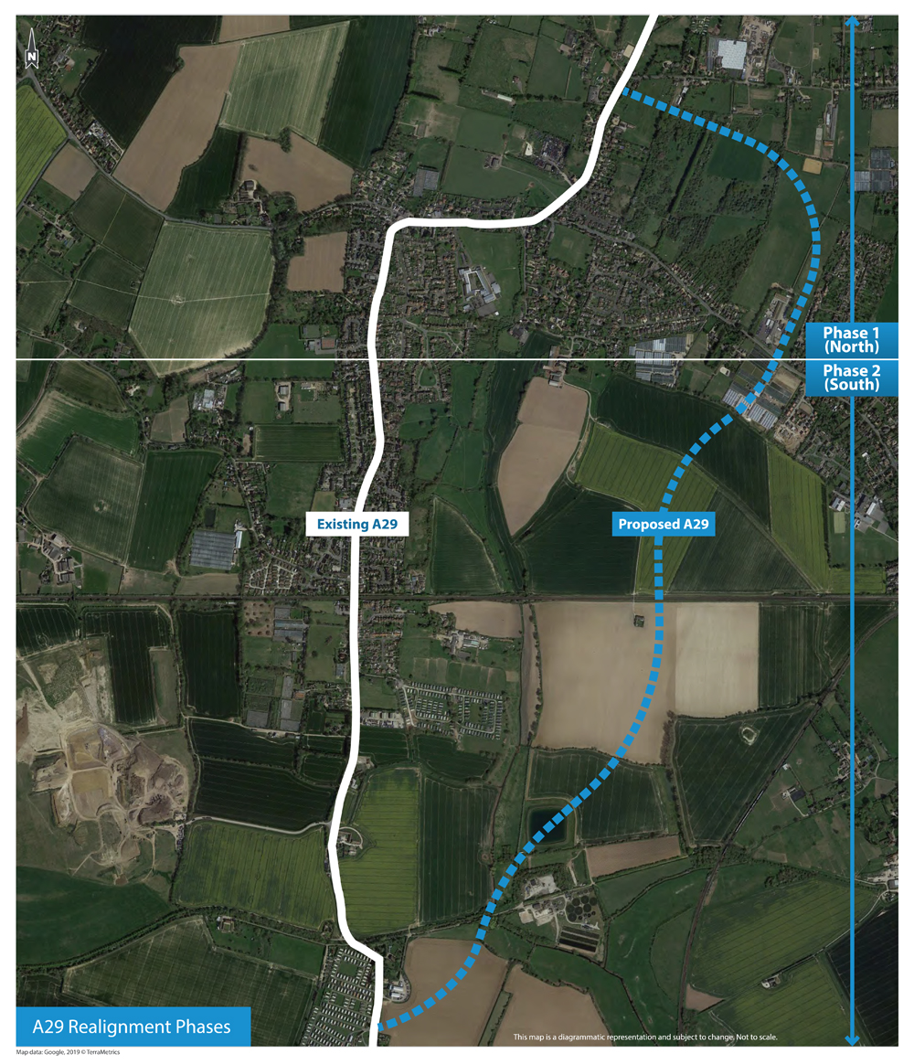
The full A29 realignment scheme will deliver a new 4.34km road to the east of Eastergate, Westergate and Woodgate villages.
The proposed new road will help to:
- provide a more reliable connection to Bognor Regis
- reduce traffic along the existing section of the A29, especially at the Woodgate level crossing and the War Memorial junction
- improve and reduce journeys, making them safer for all road users
- enable access to allocated development land in the adopted Arun Local Plan, providing access to new jobs and new homes in Arun District
The scheme will be delivered in two phases:
- Phase 1 (north) - From the A29 south of Eastergate Lane to a new junction with Barnham Road
- Phase 2 (south) - From Barnham Road to a new junction on the A29 south of Lidsey bends
The phases in relation to the surrounding area are shown on the plan below:
To manage key programme, funding, design and delivery risks, Phase 1 (north) will be procured and delivered first by West Sussex County Council.
Phase 1 (north) of the road scheme comprises the provision of:
- a single carriageway with a combined cycleway/footway
- at grade crossing points
- street lighting
- earthworks
- landscaping
- drainage and sustainable urban drainage systems associated with the scheme
- any works necessary for the mitigation of adverse impacts (including environmental and ecological)
The arrangements and approach for delivery for Phase 2 (south) are being discussed with developers through the planning process.
Scheme cost
The total estimated budget for Phase 1 (north) of the scheme is circa £25 million and construction work will be subject to procurement processes to achieve best value. The scheme is jointly funded by the Coast to Capital Local Economic Partnership, West Sussex County Council and private developer contributions.
The current cost estimate reflects increased contingency provisions, potential for future land compensation charges and increased construction cost projections due to a combination of impacts (from Brexit, COVID-19 and inflation) within the construction industry affecting materials and labour.
Public engagement and planning permission
The county council held a full public consultation for both phases of the new road realignment over a period of more than 8 weeks from 26 February to 26 April 2019.
In addition, a full planning consultation was undertaken as part of the planning application process, which is detailed under planning application WSCC/052/20 and is now closed. Planning permission was granted following a planning committee on 30 June 2021.
What we are working on now
We are currently working on:
- land agreements and external planning issues related to the development sites
- a key decision for the construction tender for the early implementation of the Barnham Road roundabout - this decision has been taken and is available to view online
- Tender period has been completed and a contractor selected, they are currently working with West Sussex County Council under a Letter of Limited Instruction for Early Contractor Involvement for advanced works, pending formal contract (awaiting land contract completion)
- early site clearance of hedgerow and trees on southern site and fencing from 23 February 2026 for 2 weeks and some trial holes and utility surveys adjacent to Halo site - this is to remove risk of nesting birds delaying a late spring start on site
Proposed phase 1 (north) timelines
The proposed timelines are:
- submission of planning condition discharge - completed in July 2022 - Completed
- detail design - completed in November 2022, with updates to include trial hole surveys completed in Autumn 2023 - Completed
- demolition of Fleurie Nursery glasshouses and ancillary buildings and hardstanding (May 2024 to July 2024) - Completed
- preparation of key decision report (November 2024 to February 2025) - Published for Phase 1A Barnham Road roundabout only
- review of design and preparation of tender documents (November 2024 to Spring 2025) - Completed - this is for Phase 1A Barnham Road roundabout only
- tender period and contractor appointment (25 April 2025 to Autumn 2025) - Completed
- period of advanced works and Early Contractor Involvement in preparation for main works (September 2025 to Spring 2026)
- preparations for potential Cabinet Member Key Decision for use of county compulsory purchase powers for land required for the Phase 1A Barnham Road roundabout (January 2026 to March 2026)
- early site clearance of hedgerow and trees on southern site and fencing from 23 February 2026 for 2 weeks and some trial holes and utility surveys adjacent to Halo site
- start of construction of the Barnham Road roundabout and Halo access, subject to land agreements, but currently anticipated to start Spring 2026
- completion of construction of the Phase 1A Barnham Road roundabout and Halo access, currently anticipated to finish Winter 2026
- remaining section of A29 Phase 1 (Fontwell to Barnham), is currently subject to ongoing discussions relating to land allocation and is anticipated to follow the construction of the Barnham Road roundabout