
A29 Pulborough Update
Find the latest information on the landslide on the A29 in Pulborough.
Latest information
28 May 2026
The A29 Church Hill Road in Pulborough will be closed on Saturday 10 August from 9.30am to 2pm. The closure will be in place between the A283 junction and Church Place.
We need to close the road so we can undertake a programmed annual inspection of the traffic lights at this location. Our team will be inspecting the lights, poles, wiring and electrical connections to make sure everything is working and operating safely.
Emergency vehicles will still be able to use the road. All other traffic will need to follow the signed diversion route while the road is closed. You can find full details on One Network.
9 April 2026
The A29 Church Hill in Pulborough will be closed from Monday 20 April for 10 days between the junctions of Lower Street and Church Place to allow for essential safety work. Read the full statement here
12 January 2026
Court Hearing for A29, Pulborough dismisses Landowners’ appeals
A recent Magistrates’ Court hearing relating to the ongoing situation on the A29 in Pulborough has resulted in the dismissal of the appeals made by the landowners.
In February 2024, West Sussex County Council served statutory notices on the landowners requiring them to undertake certain tree works on their property. These works required them to remove a number of trees which were assessed to be dead, dying or insecurely rooted so as to remove the risk of danger posed to passing vehicles or pedestrians.
These statutory notices were appealed and referred to the magistrates’ court system, however at the recent hearing, held on the 7 and 8 January 2026, the appeals were dismissed.
The county council will engage with the landowners to secure completion of relevant tree works in a timely manner.
Background information
When did this start?
28 December 2022
Actions taken by the Council since the landslide occurred:
- Establishing the road closure and diversion (please see map below)
- Improving diversion route signage, including electronic signs at key locations
- Engineers and specialist contractors are scoping potential solutions
- Further surveys are being undertaken to assess the damage to the embankment and develop options to resolve the situation
Nature of the problem
The landslide occurred at the narrowest part of the A29, where both sides are flanked by steep embankments. Geo-technical experts have assessed the embankments and advised it is not safe to reopen the road to vehicles and pedestrians – we must adhere to this expert advice as safety has to be of number one priority.
The situation is complex as disturbing material from the embankment could further undermine it and make the situation far worse. Trees are at risk of being brought down and there is the added complication of a sewer drain in the embankment which has been damaged in the landslide. This is why the County Council has not yet removed the debris from the highway.
These issues are further complicated because the Council does not own the land on which the embankments stand.
Both embankments have moved and worsened since the original road closure. The western side has seen more material join the pile of debris on the highway and the eastern side, which we have significant concerns with, has shown signs of slippage and material deposited on the carriageway.
Diversion information
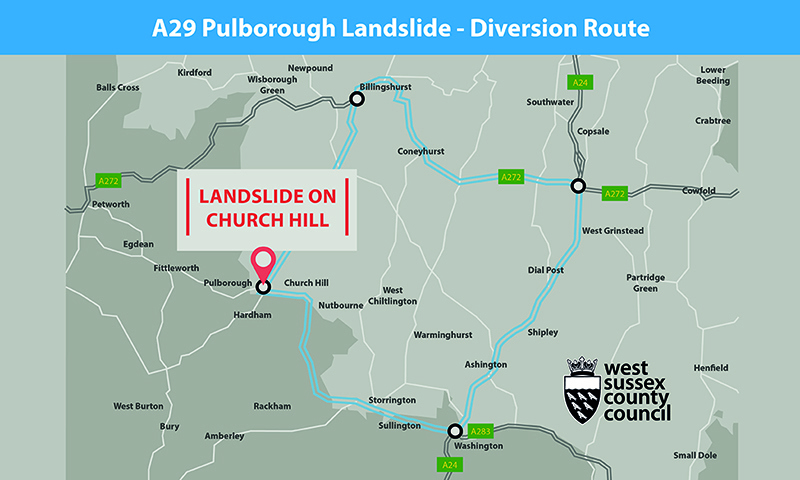
The A29 Church Hill, Pulborough is closed between the junctions of Church Place and the A283 Lower Street. Please use the official diversion route to avoid disruption to local residents. Local businesses remain open.
The diversion route is as follows:
- A283 via Storrington
- A283 via Washington
- A24 Northbound via Ashington
- A24 Northbound via Shipley
- A24 Northbound via West Grinstead
- A272 Westbound via Shipley
- A272 Westbound via Coolham
- A272 Westbound via Coneyhurst
- A272 Westbound via Billingshurst
- A29 via Billingshurst
- A29 via Adversane
- A29 Pulborough
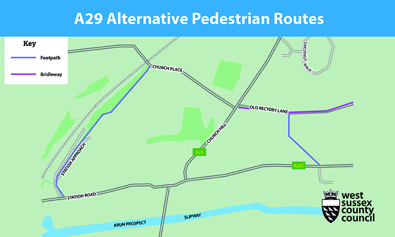
Pedestrians, please use the signposted alternative routes via Bridleway and Public Right of Way as shown in the below map. For safety reasons, please do not move the barriers to walk through the closed area.
Previous updates
18 December 2025
West Sussex County Council remains committed to resolving the ongoing situation with the A29, Church Hill in Pulborough. Whilst we have not made as much progress as we were hoping to have done this year, there is a prospect of some being made soon, with a court hearing having been set for January 2026.
31 October 2025
There will be a temporary, off-peak closure of the A29 Church Hill through Pulborough on Friday 7 November.
The road will be closed between the hours of 09:30 and 15:30 to minimise disruption to rush hour traffic.
The closure is to allow for routine detailed inspections of the trees and the embankments to safely take place. We will also be undertaking general maintenance to a number of street lighting columns.
We urge the public to not move the temporary barriers and attempt to travel through the closure for the safety of all involved.
As with previous closures, there will be a full, signed diversion route via A29, A272, A24, A283. We appreciate that this will cause some disruption to the local road network and apologise for any inconvenience.
All information about this closure can be found online at https://one.network/?GB145793283
5 August 2025
We share residents’ frustrations on the slow progress on work to safely re-open Church Hill in Pulborough.
As the land is in private ownership, we are not able to carry out any works without either the explicit permission of the landowners or a directive from the court that they are to allow us access.
The Magistrates Court held a short hearing in June, following which the full hearing of the appeal from the landowners of the affected embankments on the A29 in Pulborough will now be heard in early 2026.
Legal options to address the lack of an agreed upon solution are limited and we must allow each option to reach a conclusion before we utilise another avenue. However, the council will leave other legal routes under active consideration if this route to have the planned works approved through the courts does not provide the much-needed solution in a timely way.
The council remains committed to exploring all options to resolve the situation, including continuing to engage with the landowners if they are open to further discussion. We are also liaising with the Parish Council regarding next steps once we are in a position to make progress.
14:21 28 January 2025
The County Council served statutory notices on the owners of the land linked to the landslide on the A29 in Pulborough in an attempt to progress the situation and implement a solution by carrying out work on the embankments. The landowners stated that they would appeal these notices. A hearing took place on 6 January 2025 where the magistrates court considered an appeal by one of the landowners. The court made various orders to the landowner to present evidence ahead of a full hearing of the appeal, which is now due to be heard in June. A different process will need to apply to the other landowner.
The Council has made two specific asks of the land owners. One is to access the land in order that non-destructive testing can be undertaken so as a permanent, safe solution may be developed. The other is to access the land in order that vegetation can be managed in order to reduce the risk of further slippages. We will continue to pursue both through negotiation and as necessary the courts.
11:24 10 January 2025
A temporary road closure of Church Hill, Pulborough will take place on Tuesday 14 January between 10am and 2:30pm.
The closure is to allow for routine detailed inspections of the trees and the embankments to safely take place.
A full diversion will be in place during the closure and we will re-open the road as soon as the inspection has been completed.
16:30 19 December 2024
West Sussex County Council is continuing its efforts to resolve the ongoing situation with the A29, Church Hill in Pulborough following a landslide which occurred in late December 2022. Over this period, our focus has remained on reaching a resolution for the benefit of residents, businesses and visitors across Pulborough.
12:00 24 June 2024
The A29 at Church Hill in Pulborough will be temporarily closed on Friday 5 July 2024 to allow for a routine inspection of the site and a formal inspection of the traffic signals equipment to ensure it is operating as they should and there are no equipment issues/damage.
This closure, which is essential for the safety of both the public and workforce, is scheduled to take place after the morning’s rush hour period, starting at approximately 10am and should last no longer than four hours.
As with previous closures, there will be a full, signed diversion route. We appreciate that this will cause some disruption to the local road network and apologise for any inconvenience, however, it is necessary to allow us to monitor the situation.
04 June 2024
We share residents’ frustrations on the slow progress on work to safely re-open Church Hill in Pulborough. We have tried to resolve this in a number of ways and will continue to work on finding a solution. Until works can be carried out to both private embankments, it is not safe to re-open the road under normal conditions.
The county council has engaged regularly with the landowners to set out the works that need to be carried out, which would be at the council’s expense. Unfortunately, the landowners have not so far given permission.
This is why we decided to install the current traffic signals and concrete blocks to reduce the risk to the highway and people using it and to bring some normality back to the community in Pulborough.
We inspect the site daily to make sure these temporary arrangements are working as they should, and geotechnical engineers carry out monthly assessments to ensure there are not significant changes to the embankment that would put the highway at further risk.
We will continue to pursue an agreed solution with the landowners, but we are also continuing to make use of the powers available to us under highways legislation. These are of course subject to challenge through the courts and potential further delays, so we are also exploring other legal routes and will use them if necessary.
At this point in time we are unable to give an indication of when we expect the situation to be resolved. We will update once we have an agreed upon solution. We are continuing to work closely with the landowners involved so officers and our specialist contractors can access the private land to complete their assessments and fully design the solution.
16:37 04 January 2024
Heavy rainfall has forced the closure of the A283 Stopham Road/Station Road at Pulborough (where the road goes under the railway bridge) for the sake of public safety.
The carriageway is currently under water and the road surface is deteriorating. A diversion is being set up as follows: A29, A272, Kingspit Lane (Petworth Lorry Route), A283.
A West Sussex Highways spokesperson said: “We apologise for the disruption this will cause but safety has to be our paramount concern. Emergency work will be carried out tonight to try to resolve this, and we hope to reopen the road as soon as possible tomorrow, subject to any unforeseen complications.”
15:58 02 January 2024
An independent geotechnical report has brought into question the health of the trees on both sides of Church Hill in Pulborough.
The road is currently open under traffic-light control but will have to be closed between 9.30am and 3.30pm on January 9 so that county council tree specialists can carry out a detailed assessment.
A West Sussex County Council spokesperson said: “The assessment, with geotechnical support, will have the stability of the embankments in mind. It will aim to establish what works are needed in the short and medium term to keep this section of highway safe.
“We also plan to utilise the road closure to carry out street lighting lamp upgrades, which will avoid the need to close the road again on a separate occasion. Once the assessment is complete, we will understand if additional works are required.”
We remain committed to the full and safe re-opening of Church Hill in Pulborough. We will maintain the current traffic-light controlled arrangement, although we may need to arrange the further temporary closure as part of our on-going risk management.
The challenge the council faces in achieving a long-term solution remains the fact that the sources of the risk to the road are within two areas of privately-owned land. Legal options for this specific kind of problem are regretfully not straightforward and the issue has not been properly tested in the courts for many years, if at all. The easiest solution is to have formal agreements with the landowners.
The council entered negotiations with the landowners, supported by technical reports to fully describe the problem and how to manage it. Those did not lead to an agreed plan of action. It has therefore been necessary to consider other, more significant legal steps to gain access to the land to carry out the necessary works so that the highway can be fully re-opened. This has required further technical assessments which have reinforced the council’s concerns and proposals.
The council will continue to engage with the responsible landowners so that it can take a final decision whether to deploy the more significant legal option that provides the best chance of success.
Meanwhile, and for as long as the plans take to follow through, the council will continue to monitor the situation along the route and may need to arrange temporary closure of the route in response to severe weather warnings.
14:58 06 November 2023
Following an assessment carried out by our Highways team and signals contractor this morning, we can confirm that the A29, Church Hill, has now been re-opened.
14:15 03 November 2023
Following an assessment this morning, Friday 3 November, and based on the forecasted weather over the weekend, the decision has been made that the A29 Church Hill, Pulborough will remain closed over the weekend. The road remains closed as a precautionary measure, with the ground remaining very saturated and a prediction of up to 40mm of localised rainfall over the weekend. A further assessment is scheduled to take place on the morning of Monday 6 November with the expectation that the road will be re-opened by 3pm.
16:05 01 November 2023
Short-term closure of A29 in Pulborough due to Met Office weather warning causing safety concerns
Due to the amber weather warning issued by the Met Office for anticipated high winds and rainfall, we will be closing the A29 Church Hill from 9pm today, Wednesday 1st November. This is a precautionary measure due to the concerns for highway safety with potential tree damage and the impact this may have on the already unstable embankments.
The duration of the closure will vary depending on how badly the storm affects this area, however it is expected that the road will be open from midday on Friday 3rd November following an inspection to assess the trees and embankments on Friday morning.
The road will be closed using fencing and barriers, and the temporary traffic signals will be switched off during the closure. We urge the public to not move these barriers and attempt to travel through the closure as it has been put in place for your safety. During the closure a full signed diversionary route will be in place.
We will endeavour to provide any further updates as soon as possible and circulate to the wider public via this dedicated page and our social media accounts.
08:34 25 October 2023
Short-term closure of A29 in Pulborough for pre-winter assessment work on Friday, 27 October
With winter approaching, we need to carry out further, detailed assessment of the embankments adjoining the A29 at Church Hill in Pulborough.
For the safety of both the public and workforce, a short-term road closure is essential. It will start at 10am on Friday (27 October) and should last no longer than three hours. As with previous closures, there will be a full, signed diversion route. We appreciate that this will cause some disruption to the local road network and apologise for any inconvenience.
10:40 08 August 2023
WSCC continues work to resolve ongoing situation on the A29 at Pulborough
The county council fully understands its responsibility to secure the safe re-opening of the full route of the A29 at Pulborough following the landslide.
We are unable to fully re-open this section of the road due to ongoing danger posed by the unstable nature of the steep embankments on either side. The embankments are in private ownership and the council does not have legal rights to enter or carry out work required on this private land. The most common and quickest solution is to secure the permission of the landowners through a licence, with the council agreeing to meet the costs and carry any liabilities associated with the work. Officers from the council have been working very hard to secure the agreement of the two landowners but this unfortunately have not been successful.
As an agreement has not be secured, other legal options have been considered however they all require the use of the courts. In March, the council issued notices to the landowners under s.151 Highways Act which required them to carry out the works. The landowners have appealed those orders to the Magistrates Court, with no hearing of these appeals being listed to date. The notices cannot take effect until the appeal has been heard and determined by the court.
As the situation is no closer to a clear resolution, the council is also considering other court routes to enable it to be resolved and will keep residents and stakeholders informed of the progress of these as updates are available to provide.
In the meantime, the single lane signal controlled arrangement is now being remotely monitored and will be regularly reviewed to ensure it provides a workable temporary solution.
27 July 2023
Due to ongoing concerns with the private embankments adjacent to the A29, Church Hill, we are undertaking monthly inspections to ensure that there have been no significant changes at the site which may increase the risk to anyone using this section of road. After the morning’s rush hour period on Friday 28 July, both traffic signals will be held on red for a short period of time, approximately 5 mins to allow the engineers to safely carry out the inspection. We are aware that this will cause some disruption however, it is necessary to allow us to monitor the situation and the signals will then operate to clear any queuing traffic as efficiently as possible.
We apologise for any inconvenience this causes and we are grateful for your patience.
9:45 7 July 2023
The new traffic signal-controlled system introduced this week will initially adopt the timings that were refined under the manually controlled temporary lights since their deployment in April 2023. Unlike the previous temporary lights, the new arrangement is more intuitive and adapts to traffic flow fluctuations. Traffic detection cameras help monitor queue lengths at either end, adjusting the green time given in each direction until either the demand is serviced or the maximum timer has elapsed.
The timings and performance of the signals will be under continuous review. We have installed CCTV cameras at either end of the narrowing which can be accessed remotely on a live feed to enable more flexible and reactive opportunities for adjustments to be made.
An additional feature has been installed to help support the engineers whilst onsite to walk from one end of the narrowing to the other by holding vehicles at both ends at red. If the regular wait time is longer than expected, please be aware that this may be because the engineer is onsite and requiring access, so please be patient.
We will be installing more pedestrian signs at key locations to improve the alternative route signage. All non-vehicular traffic is reminded that it is not safe to travel through the narrowed section of Church Hill and should use the alternative routes.
16:37 23 June 2023
Advance warning that we will be updating the temporary traffic signal arrangement on the A29 at Church Hill, Pulborough, with a more sophisticated vehicle activated system. To implement this, we will need to close Church Hill for 2 days, on the 3 and 4 July 2023, and will revert to the previous diversion route. Whilst we acknowledge that this closure will result in some local congestion and issues, the closure is necessary for the safety of the contractors delivering the works.
10:34 16 May 2023
The temporary single lane solution with 2-way lights on Church Hill is continuing to operate effectively with minimal congestion and reasonable queuing times. The manual control of the lights currently remains in operation to ensure a good flow of traffic through the area. We are monitoring traffic volumes and flow through Church Hill.
The Council continues its discussions with the two landowners to secure their agreement to the Council entering their land to carry out the works needed to make the road safe from further landslips before it can be fully re-opened.
We are aware of the condition of some side roads which were impacted by the increased traffic volumes during the closure of Church Hill. We are still carrying out additional highways inspection in the area to identify safety defects that meet our criteria for intervention. In the last month we have identified and repaired 9 potholes on New Place Road and a further 9 on Rectory Lane.
Looking longer term, we have identified the areas of concern on these impacted roads, and are in the process of exploring what level of works are required to resolve the current condition issues and plan when we are able to deliver improvements whilst minimising delays and disruption.
The parking restrictions on New Place Road have now been lifted with all ‘No Parking’ cones removed accordingly.
11:19 18 April 2023
The A29 in Pulborough is now partially re-opened with all vehicular traffic permitted to travel in both directions along Church Hill. 2-way traffic signals to control the direction of the flow are situated in advance of the narrowing created by the concrete blocks and will be manned throughout the day.
Experienced operatives will be located at either end of the narrowing. The operatives will constantly be in radio contact to manage the lights depending on the vehicle volumes and priority of traffic flow.
Having assessed the traffic management options for the partially re-opening, the 2-way traffic light option is considered the safest. We are aware that the two-way option will result in traffic queuing at either end, however we feel that the addition of manual controlling of the traffic signals at peak hours will minimise the disruption these queues may cause. We will continue to monitor the situation.
14:23 14 April 2023
Work to progress the single lane re-opening of the A29 at Pulborough continues, with the road scheduled to re-open on Tuesday 18 April by 11am. All vehicular traffic will be permitted to travel in both directions, with traffic signals controlling the direction of the flow.
14:50 30 March 2023
A29 at Pulborough to partially re-open
West Sussex County Council will re-open the A29 at Church Hill, Pulborough, following prolonged closure due to landslips.
The council will start work on opening one lane of the road to traffic, utilising concrete blocks to create a protected, single lane carriageway down the centre of the road. A contractor has been mobilised to start the work shortly with work taking approximately two weeks.
15:07 17 March 2023
WSCC Highways team responded to an emergency situation of a fallen tree on Broomers Hill Lane, Pulborough. The road was closed for safety while the tree and resulting debris is cleared. Teams are on site this afternoon to make the area safe and re-open the road to 2 way traffic.
11:17am 7 March 2023
We are aware that Southern Water are currently carrying out emergency works on the A29 Stane Street / New Place Road to fix a burst water main. The repair work started last night and currently temporary traffic lights are in place. These lights will be removed once the repair is complete. Please plan your journey accordingly.
9:20am 3 March 2023
West Sussex County Council has thanked all those who attended the public meeting about the A29 closure on Monday 27 February. We appreciate those who took the time to engage with our representatives and ask questions about the landslide and resulting closure. It was a useful and insightful meeting which we took a lot away from.
We fully appreciate the frustrations felt by local residents about the ongoing situation and the resulting inconvenience along with the hardship felt by businesses in the area. Please be assured that the County Council is doing everything it can to progress a solution to this issue as quickly as possible.
12:54pm 23 February 2023
West Sussex County Council are pro-actively engaging with local landowners regarding the ongoing situation on the A29 near Pulborough. We regularly have representatives present in the local area, either working with the relevant parties to get a solution agreed and implemented, monitoring the temporary measures that have been put in place (e.g. diversion signage), or completing repairs required as a result of the increased traffic through local roads. We have also set up this dedicated webpage which is regularly updated when new information is available, issue press releases to the local media outlets when significant updates need communicating and have a dedicated email inbox (a29landslip@westsussex.gov.uk) for enquiries relating to the closure. We will continue with these communication channels until the road is fully re-opened.
We have increased the frequency of the routine highway inspections on not only the official diversion route but also those roads being used locally to access the A283 and the A29. These include Rectory Lane, Link Lane, New Place Road, Broomers Hill Lane and Gay Street Lane. Once identified, safety defects (e.g. potholes) are being prioritised by the contractor to expedite repair works.
For issues relating to driver behaviour such as cars mounting pavements and motorcycles revving up the street throughout all hours, we recommend contacting Sussex Police via Operation Crackdown.
11:31am 14 February 2023
Monday 6 February saw the installation of concrete barriers to the northern end of the closure. The barriers are being installed following an incident in the early part of this week where a motorist moved the barriers and fencing at both ends of the closure and proceeded to drive through. We would like to remind people that the closures have been put in place for everyone's protection and urge people to follow the signposted vehicle and pedestrian diversion routes.
14:27 pm 3rd February 2023
Tonight (3/2/2023), working collaboratively with our drainage crews, we will be closing Broomers Hill Lane to complete the outstanding pothole repairs. The closure will take place overnight to minimise any further disruption to the network.
11:00 am 1st February 2023
We have introduced temporary parking restrictions through New Place Road to aid traffic movements and release any bottleneck on Link Lane particularly around school pick and drop off times. We continue to monitor those surrounding roads and review traffic matters.
We have increased the frequency of the routine highway inspections on not only the official diversion route but also those roads being used locally to access the A283 and the A29. These include Rectory Lane, Link Lane, New Place Road, Broomers Hill Lane and Gay Street Lane. Once identified safety defects (e.g. potholes) are highlighted, these are being prioritised by the contractor to expedite these works.
We have requested additional signage to the north of Billingshurst for vehicles travelling south advising motorists to seek an alternative route (A272) before attempting to navigate Billingshurst and proceeding onto the A29. This reinforces those signs already at the junction to the A272 towards the Wisborough Green turning.
We have also requested additional signs that will provide pedestrians an alternative route to the closure as we have seen a number of pedestrians moving barriers and walking through the closure. We are hopeful that both requests for additional signs will be installed by end of play Monday.
16:21pm, 23 January 2023
Our Highways teams continue their hard work to find solutions to the complex situation following the A29 Pulborough landslide, where an embankment collapsed. Every effort is being made to ensure the stretch of the A29 impacted by the collapse is made safe so it can be re-opened as soon as possible.
County Council representatives have undertaken an inspection of the traffic management in place, along with the “unofficial” alternative routes. We will continue to monitor the situation and assess any need for alternative traffic arrangements.
The surrounding roads are continuing to be subjected to additional inspections and any defects identified are then being prioritised due to the unprecedented amount of traffic that is using these roads.
You can also visit the Pulborough Parish Council webpage where they are posting updates when available.
Claims for compensation
As the reasons for the closure of this section of the A29 road through Pulborough are not due to any fault or failing of the Council, it is not able to draw on public funds to compensate anyone who may be losing income. The Council is doing everything it can to secure the safe re-opening of the road. It has also done what it can to ensure diversions are in place and well advertised. The Council is aware of the value of this route to local people and businesses and will continue its work to get the road open.
Press
Press releases
- Release date: 18 December 2025 County Council continues to pursue resolution to ongoing situation on A29, Pulborough
- Release date: 19 December 2024 County Council committed to resolving the ongoing situation on A29, Pulborough
- Release date: 26 June 2024 Advanced Notice of a temporary closure A29 Church Hill, Pulborough on 5 July 2024
- Release date: 2 January 2024 A29 Church Hill, Pulborough, update: essential, six-hour closure on 9 January